

SEA Laboratory
The Sea Lab, dedicated to the study and monitoring of the marine environment, will facilitate the coordination of the various regional monitoring systems already in existence in the Alto Tirreno - Mar Ligure region. This will meet national and international demand for the protection of the marine environment and its potential for innovation and growth (Marine Strategy and Blue Growth).
ACTION
Creating a regional centre to calibrate, compare and test tools and platforms (primarily as a "virtual network" of existing ones).
Members will be able to calibrate instrumentation and share tools.
- Management, processing and use of environmental data and of information from digital models. Environmental data will be subject to a quality validation system according to international protocols and standards (IOC-UNESCO and WMO).
- Studies of human impact on coastal and port areas to incentivise the implementation of European directives and/or national/regional laws (e.g. ecosystem approach and environmental status evaluation).
- Realization of a regional network of experimental marine stations.
- Sustainable technological development in the marine and maritime transport sector.
SEA STATION
In order to support the activities of the ship and sea laboratories, an agreement was signed between DLTM and INGV - the coordinator of the EMSO infrastructure - for the realization of an underwater observatory station (SEA) with the following aims:
- Depth measurements
- Water column measures
- Measurement and monitoring of noise emissions and contaminants
The sea station will place DLTM and its members in an international context, and will also link to the pan-European networks SeaDataNet and EMODnet to share and manage marine and oceanic data.
SHIP Laboratory
Progettiamo la nautica del futuro!
Il Laboratorio NAVE concentra la propria attività sul supporto alle azioni innovative dei propri associati inerenti:
- Fluidodinamica computazionale (CFD)
- Calcolo strutturale con metodo ad elementi Finiti (FEM)
- Prototipazione e Stampa 3D
We design the ships of the future!
The ship laboratory supports innovative projects by its associates:
- Computational fluid dynamics
- Structural calculation using finite elements method
- 3D prototyping and printing
The laboratory can provide a wide range of opportunities to associates, such as:
- Specific assistance in the use of advanced digital simulation tools, both commercial and non-commercial, which are also made available through the HPC platform as software as a service.
- Research and development using open-source software application
The laboratory's priority is to produce patents and scientific publications, and to support graduate theses, in collaboration with the University of Genoa.
PUBLICATIONS
MARINE 2015 – “On the fluid dynamic design and optimization of sailing yacht hull and appendages using a complete open soure framework” (G.Bailardi, J.Guerrero)
Naval Architecture preserves both the sketching conceptualism and the engineering pragmatism. As a matter of fact, the heuristic approach behind a sailing yacht technology comes from a tangible amount of experience and knowledge. In this respect, Design and Analysis of Computer Experiments (DACE) represents an efficient tool for improving the overall knowledge on parameter dependency, while a Multi Objective Optimization easily reveal the best choice according to specific project constraints. In this work we propose a fully automated and parametric simulation framework, entirely based on Open Source technology. From an engineering and practical point of view, it is important to understand the real applicability of these tools on complex engineering tasks, such as evaluating the aero- and hydro-dynamic performance of sailing yachts. Due to its r eliability, scalability and cost effectiveness, the use of a simulation and optimization framework based on Open Source software represents an attractive option for engineers and designers looking for the best return-of-investment. In order to create the parametric geometry we use SALOME and OpenVSP, while mesh generation and fluid dynamics simulation are based on \OpenFOAM technology. The DACE optimization loop and the meta-models construction is done using DAKOTA.
NAV 2015 – “An Open Source Framework for CFD Optimization: the case of Sailing Yacht Daggerboards” (G.Bailardi)
Today, a large amount of Open Source software have been developed and from an engineering and practical point of view, it is important to understand the real applicability of these tools in performing and completing complex engineering tasks. In this work, the three-dimensional model to be studied, the domain discretization, the solution of the governing equations, and the data analytics have been performed entirely by using a simulation and numerical optimization framework based on Open Source technology. As parametric geometry modeler, the Open Vehicle Sketch Pad was employed, and for mesh generation we used the freely available CfMesh tool. The CFD simulations were carried out using OpenFOAM solver, while the numerical experiment and the subsequent Surrogate based Optimization was done by means of DAKOTA optimizer. For data post-processing and plotting we used Octave and Python.
SEAMED 2014- “Seakeeping analysis of sailing yacht hulls and center-board effect by BEM and CFD approaches” (G.Bailardi, D.Boote)
The seakeeping of a floating body, whether in motion or simply standing still, is recently becoming a crucial part in the design and the engineering process from large passenger ships to racing sailing yachts. Offshore structure as well, are influenced by motions induce by waves. Moreover, even if the importance of the experimental tests is still undoubtedly relevant, nowadays several numerical methods allow to predict, with more or less accuracy, the boat behavior in regular and irregular wave field.
FOR INFORMATION
- Andrea Martinelli: This email address is being protected from spambots. You need JavaScript enabled to view it.
- Giovanni Bailardi: This email address is being protected from spambots. You need JavaScript enabled to view it.
HPC Lab: High Performance Computing
The DLTM high-performance computing (HPC) centre offers resources and services that solve complex problems using parallel computation, in basic and applied research in areas involving high-tech systems simulation and design.
It provides tools and resources to the following research and manufacturing sectors:
- Fluid dynamics/hydrodynamics
- Structural computing
- Design and simulation
- Digital modelling
- 3D modelling and rendering
- Big data
Its activities focus on:
- Parallel computing support;
- Consultancy service for HPC architecture design and/or management;
- Processing, management and analysis of Emso station data (sea lab);
- Big data, support for the use of SkyLable object open source storage.
COMPUTING CENTRE
The supercomputing centre is the essential infrastructure resource on which the centre's three laboratories are based (ship lab, sea lab, HPC lab).
The district has a Dell cluster, purchased in July 2016, consisting of a hybrid HPC and cloud architecture, in turn made up of the following:
- HPC Cluster
- Hw:
- 18 computing nodes (Dual CPU - Intel 52695 V3 2.4 Ghz) each with 28 cores and 64 GB of RAM, giving a total of 504 cores and more than 1 TB of RAM
- Mellanox INFINIBAND 56 Gb/s FDR high-performance connection infrastructure
- 1 Head Node with 24 cores and 386 GB of RAM
- 2 NVIDA K40M cards
- High-performance shared storage, 21 TB of net space.
- Computing power (excluding GPU): more than 17 teraflops
- System SW:
- Bright Cluster Manager
- CentOS 7
- PBS Pro
- Principal libraries and compilers
- Hw:
- Private Cloud
- Hw 4 nodes (Dell FC630):
- Dual CPU Intel E52650 v3 with 128 GB of RAM
- For a total of: 80 cores and 512 GB of RAM
- Hw 4 nodes (Dell FC830):
- Four CPU Intel E54620 v3 with 256 GB of RAM
- giving a total of 160 cores and 1 TB of RAM
- The cloud resources pool has a total of 240 physical cores and 1.5 TB of RAM
- High-performance storage based on MS storage spaces in Scale Out File Server with 55 TB and 2.9 TB SSD for the cache.
- System SW:
- System Center 2012 (soon to be upgraded to 2016)
- Azure Pack portal
- Number of unlimited licenses of Windows Server 2012 and 2016
- Hw 4 nodes (Dell FC630):


SERVICES
High-reliability HPC resources for a high level of processing power (CPU and memory intensive), sold in pay-per-use mode, based on a list available from This email address is being protected from spambots. You need JavaScript enabled to view it.
Members of DLTM, research bodies and non-profits receive a special discount on the list price.
The following CFD and FEM simulation software is available in SaaS mode on the HPC cluster, including for commercial use:
- Ansys CFD (Ansys CFX, Fluent) and Ansys Mechanical
- Starccm+
- MSC suite (Nastran, Patran, Marc, Apex, etc...)
- OpenFOAM
On request, we can install any other software that uses parallel architecture.
The computing will be performed in batch mode, and, on request, the user will be able to use a virtual graphics workstation for the calculation and/or realisation of the Mesh.


![]()

High-reliability, high-performance cloud resources are offered by the Microsoft infrastructure, which delivers IaaS services using virtual machines to meet user needs, both with Windows Server 2016 (with unlimited licences) and Linux for any type of software and service sold to third parties, for example:
- Web server
- Database
- Gestionalewindows--2016 server
- Machine learning
- Big data

For more information, write to the laboratory coordinator: This email address is being protected from spambots. You need JavaScript enabled to view it.
SEA Lab English
The MARE LAB
The Marine Environmental Monitoring Station realization project is the result of the cooperation between all public research institute and universities associated with the DLTM to create an advanced monitoring system, complementary to the existing ones in Ligurian sea. This is possible making a common factor human resources, infrastructures and equipment, contributing to the costs of maintaining efficiency.
For the preliminary and executive design of the Project, DLTM has selected, through an appropriate public procedure, an expert consultant (Hydra Solutions) for the systems design operating in marine environment.
With the support of Hydra Solutions and the interested EPRs, DLTM has completed the detailed definition of the infrastructure layout, which consists of two modules: a coastal station, called "Mooring Costiero" and an offshore structure, called "Levante Canyon Mooring ".
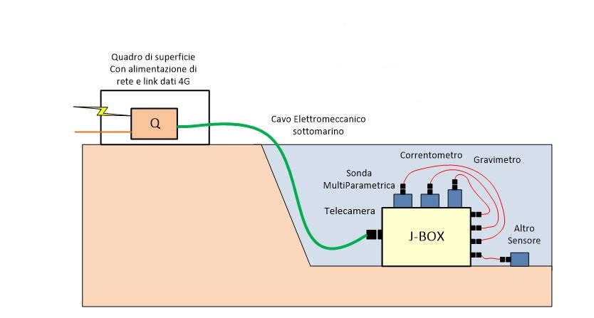
COASTAL STATION "MOORING COSTIERO”
A hi-tech observatory wired at 10 meters depth with real-time data acquisition, equipped with a CTD profilator probe, whose main feature is to allow real-time visualization of data related to conductivity, pressure and temperature; a sophisticated gravity meter for measuring gravity acceleration; a correntometer consisting of a propeller free to rotate that creates impulses proportional to the speed of the water; a digital underwater camera to monitor the underwater ecosystem and special cages for studying the degradation of plastics and the absorption of pollutants in the marine environment. This innovative submarine observatory was installed on 03/04/2020 at Santa Teresa Bay (La Spezia) by the Ligurian District of Marine Technologies (DLTM) together with ENEA, CNR, INGV, with the support of Cooperativa Mitilicoltori Associati and Comune di Lerici.
Among the parameters monitored, those of water conductivity, pressure and temperature have as their main purpose environmental monitoring and the study of the effects of climate change, whereas the Western Mediterranean Sea has witnessed numerous mass mortality events involving various aquatic invertebrate species. The first major mass mortality event occurred at the end of the summer of 1999, when about 30 species of invertebrates were severely damaged for more than 500 km of coastline (from the Eastern Ligurian Sea to the coast of Provence in France and the Balearic Islands in the north coast of Menorca in Spain), other similar events of mass mortality were observed in the summer of 2003 and 2018 always associated with high water temperatures.
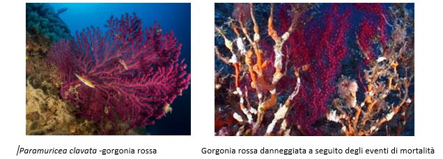
In 2003 in the Gulf of La Spezia was recorded an increase of temperature of about 2°C to 20 meters of depth, this led to mortality events that totally damaged in some cases and partially in others a large part of the community of the population of the paramuricea Ottocorall clavata (red gorgonia) on the seabed of the Tinetto island, in the west area of the Gulf of La Spezia.
Having, therefore, an instrument like the CTD, that returns in continuous data on the health of our sea, allows us to monitor the evolution and to have information of all the marine-coastal ecosystem of the Gulf of La Spezia, also to the ends of fundamental importance for the protection, integrated management and exploitation of its marine ecosystem resources. Moreover, considering that the chosen site for the installation of the observatory is close to the mouth of the Port of La Spezia, the presence of the correntometer turns out of fundamental importance in order to monitor the speed of the current to the mouth itself of the port, for the construction of coastal current models for the construction of coastal defence works and for the study of sedimentary transport phenomena during dredging works.
Moreover, the infrastructure can also be used by companies and research institute, as a real laboratory of experimentation to test cutting-edge technologies and innovative underwater sensors. The wired connection of the infrastructure will also allow real-time viewing of the captured geophysical and oceanographic images and data.
OFFSHORE STATION "LEVANTE CANYON MOORING "
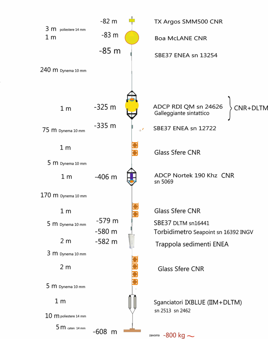
The offshore station "Levante Canyon mooring" is a system of multidisciplinary monitoring offshore for the acquisition and processing of geophysical and hydro-oceanographic data of the Ligurian Sea, deployed at sea 23rd September 2019 offshore Cinque Terre coast, and realized from Ligurian District of the Marine Technologies (DLTM) in collaboration with the research Entities CNR, ENEA, INGV, with the support of the Hydrographic Institute of the Italian Navy. This observatory, located at about 600 m of depth in an underwater canyon, will promote the study of climate change, the protection of marine ecosystems and the mitigation of natural risks related to human activities.
Specifically, the observatory "Levante Canyon mooring" consists of an instrumented chain dedicated to geophysical and oceanographic monitoring in the deep sea of parameters such as salinity, temperature, turbidity and current speed for the study of the water bottom and column. Starting from the bottom upwards, the offshore monitoring station is characterized by a sediment trap placed at 582m of depth, which will allow to obtain information of the sediments and nutrients contribution, which are channeled into the canyon and come from the continental shelf. A torbidimeter at 580m depth that has the purpose of recording the turbidity of the water ( the instrument detects the light diffused by the particles suspended in the water, generating a response proportional to the turbidity or to the solids suspended in it). Then there are sensors of conductivity, temperature and pressure placed at three different depths, respectively 579m, 335 m and 85m, in order to be able to compare the data along the water column.
It must be kept in mind that the temperature of the sea water does not have a uniform distribution along the water column, which is affected by the warming of the sea by the sun rays. In particular, below the surface, the water layers are divided into three different zones:
- depth between 50 and 200 meters - with temperatures similar to the surface;
- depth up to 1000 meters, the temperature decreases rapidly;
- depth over 1000 meters, temperature decreases gradually.
The zone in which the maximum temperature variation with the depth occurs is called "thermocline". It is however difficult to determine the exact depth of the thermocline, so an approximation is used considering it as a water belt where the vertical thermal gradient (the temperature variation with the depth) is very high compared to the upper and lower layers.
In the Mediterranean Sea the seasonal trend of the water temperature conditions the fauna habtats that have to adapt to these different conditions during the year. In the winter months the superficial layers are rather cold due to the low insolation and the action of the winds. When the sea cools between March and April, surface water masses sink and through convective motions carry with them nutrients and oxygen in depth. With the progressive increase in solar radiation, in spring, the surface layers heat up, generating a growing thermal contrast with the deep waters. Instead, during the summer, the temperature of the water tends to stabilize, thanks also to the surface currents produced by the wind that separate the warm and less dense waters on the surface from the colder ones in depth. Under these conditions the thermocline is well delimited and is usually found between 15 and 40 meters deep. The first metres below the surface are characterised by temperatures above 18°C and by good water oxygenation. The underlying layer of the thermocline has a temperature that varies very slowly and is characterized, in the summer months, by poor oxygenation as it remains isolated from the atmosphere by means of the thermocline itself. It’s clear that rising seawater temperatures can have an impact on these balances, which can also impact the ecosystems that depend on them for nutrient and oxygen supply.
The offshore mooring also includes two acoustic corrections placed respectively at 406m and 325m depth, useful to obtain information, integrate and compare the data related to the current speed in two separate and significant points of the water column. This instrument measures the speed and direction of the current, on several predetermined dimensions along the water column, through the emission of acoustic waves thanks to the "Doppler" effect. In practice the instrument sends acoustic waves at a constant frequency, when they encounter the suspended particulates they bounce and are reflected back. If the particle that is hit by the wave front is moving away from the instrument, the reflected wave will have a lower frequency than that incident, vice versa if it is approaching the reflected frequency will be greater. Thanks to the Doppler effect, given the difference between the frequency emitted and the received, the acoustic current meter is able to calculate the speed with which the particles move and consequently the water currents.
The Levante Canyon Mooring then provides the instrumentation necessary for anchoring on the bottom, the flotation and the acoustic uncouplers for recovery, useful to bring back to the surface the entire instrumented line, during routine or extraordinary maintenance.
The installation of this mooring was made possible thanks to the oceanographic ship of the CNR "Dallaporta", allowing the positioning of the observatory at about 6.5 nautical miles off the Cinque Terre Sea Park, where the depth reaches the 600 m. This stretch of sea constitutes an exclusive point of marine observation, not only because it is placed inside the "Sanctuary pelagos", zone with high concentration of cetaceans, but also for the presence of an underwater canyon that, due to the strong background currents and the considerable contribution of sediments and organic substances, it creates an environment favourable to the development and growth of valuable ecosystems such as deep corals. A joint study ENEA and IIM in 2014 in fact highlighted with the support of a ROV (remote-controlled submarine) the presence of living white corals at a depth of about 570 m. These organisms give origin to deep ecosystems with high biodiversity, but are strongly impacted by bottom trawling and must therefore be preserved because of also their considerable scientific interest.